


Bylar, Fayette County, Alabama
About
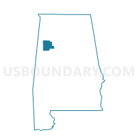
Outline

Summary
| Unique Area Identifier | 521813 |
| Name | Bylar |
| County | Fayette County |
| State | Alabama |
| Area (square miles) | 31.82 |
| Land Area (square miles) | 31.75 |
| Water Area (square miles) | 0.07 |
| % of Land Area | 99.79 |
| % of Water Area | 0.21 |
| Latitude of the Internal Point | 33.64961840 |
| Longtitude of the Internal Point | -87.68277800 |
Maps


Graphs
Select a template below for downloading or customizing gragh for Bylar, Fayette County, Alabama


Neighbors
Neighoring Voting District (by Name) Neighboring Voting District on the Map
- Berry, Fayette County, AL
- Clear Creek, Fayette County, AL
- Fords, Fayette County, AL
- Ridge, Fayette County, AL
- Samantha Fire Dept-New Lexington Voting Blg, Tuscaloosa County, AL
- Stonewall, Fayette County, AL
- Stough, Fayette County, AL
Top 10 Neighboring County Subdivision (by Population) Neighboring County Subdivision on the Map
- Fayette CCD, Fayette County, AL (8,553)
- Samantha CCD, Tuscaloosa County, AL (5,182)
- Berry CCD, Fayette County, AL (3,550)
Top 10 Neighboring Unified School District (by Population) Neighboring Unified School District on the Map
Top 10 Neighboring State Legislative District Lower Chamber (by Population) Neighboring State Legislative District Lower Chamber on the Map
Top 10 Neighboring State Legislative District Upper Chamber (by Population) Neighboring State Legislative District Upper Chamber on the Map
Top 10 Neighboring 111th Congressional District (by Population) Neighboring 111th Congressional District on the Map
Top 10 Neighboring Census Tract (by Population) Neighboring Census Tract on the Map
- Census Tract 101.03, Tuscaloosa County, AL (6,727)
- Census Tract 203, Fayette County, AL (4,054)
- Census Tract 204, Fayette County, AL (3,550)